ATPL Topic. Radio Navigation

Introduction to Radio Navigation
Imagine pinpointing your location, following a precise course, or even landing safely in low visibility — all with the help of invisible radio waves! This is the power of radio navigation, a fundamental skill for any pilot.
Radio navigation can be compared to an invisible guide in the sky. It allows pilots to determine their position and navigate safely using radio signals from ground stations. This is crucial for both visual flight (clear skies) and instrument flight (limited visibility) in various weather conditions.
Now that you understand the importance of radio navigation, let's explore the topic's key components in more detail.
What it is
Unlike visual navigation, which relies on landmarks or celestial bodies, radio navigation depends on radio waves emitted by ground stations. These radio signals can be used to:
- Determine the aircraft's position relative to a known location (e.g., VOR stations)
- Follow a specific course (e.g., NDB)
- Measure the aircraft's distance from a specific point (e.g., DME)
- Land safely in low visibility conditions using an Instrument Landing System (ILS)
Radio navigation offers such advantages over visual navigation as
- Accuracy, as transmitted data is precisely correct.
- Reliability, as radio waves are not affected by weather conditions or night time.
- Coverage, as radio navigation systems maintain accurate coverage over vast areas, allowing for safe navigation even in remote regions.
How it works
Various types of radio navigation systems operate on different principles, but the general idea involves:
- Ground stations send out radio signals in specific patterns.
- Onboard equipment in the aircraft receives these signals and interprets them to provide navigational information displayed on instruments in the cockpit.
And at the end, let's clarify one huge moment — the difference between general navigation and radio navigation. Both are essential tools in your aviation toolbox, but they serve different purposes.
Lastly, let's address a distinction between two essential navigation tools: general and radio navigation. While both are crucial elements in your aviation toolkit, they fulfil distinct purposes.
General vs. Radio Navigation

Think of general navigation as the old-school method of finding your way around. It relies on a combination of visual landmarks like mountains, rivers, or even distinctive buildings on the ground to pinpoint your location. This involves calculating your position based on your starting point, heading, speed, and time elapsed. It's like estimating how far you've travelled since you left home. As a result, as a pilot, you use a combination of visual references and dead reckoning to navigate along a planned route.
Radio navigation, on the other hand, leverages the power of radio waves to provide more precise and reliable navigation information. Radio aids help pilots fly more direct routes and maintain optimal flight paths, saving time and fuel.
Think of it like this:
- General Navigation: Like using a basic map and compass.
- Radio Navigation: Like having a detailed GPS that guides you turn-by-turn.
While general navigation skills are valuable for any pilot, radio navigation takes things a step further, especially in poor visibility conditions or complex airspace. You'll be using both techniques throughout your flying career, but understanding their strengths and weaknesses will make you a safer and more confident pilot.
Common Radio Navigation Systems
Here are some of the most widely used radio navigation systems in aviation:
VOR (Very High Frequency Omnidirectional Range) provides the aircraft's bearing (radial) to a known station.
NDB (Non-directional Beacon) provides a bearing from the aircraft to a known station but without directional information.
DME (Distance Measuring Equipment) monitors the slant distance between the aircraft and a DME station.
ILS (Instrument Landing System) delivers precise horizontal and vertical guidance for landing in low visibility conditions.
GNSS (Global Navigation Satellite System) utilises a constellation of satellites to provide highly accurate three-dimensional position information anywhere on Earth. Systems like GPS and Galileo fall under this category.

Exam Overview
- Number of Questions: 66
- Exam Duration: 1 Hour 30 Minutes
- Difficulty: Medium
- 86% of papers passed
Understanding different radio navigation systems and their functionalities is a fundamental part of pilot training. It's heavily tested in the Airline Transport Pilot Licence exam.
This 66-question exam examines your knowledge of radio navigation principles, systems, and procedures. Among aviation students, it's considered moderately challenging compared to the 13 ATPL subjects. According to the statistics, around 86% of examinees pass the Radio Navigation exam successfully, scoring 75% of correct answers and a higher.
Keep in mind, the minimum passing score for each ATPL exam is 75%; any score below this threshold, including 74.9%, results in a 'Fail'.
"Radio Navigation is a subject that rewards consistent practice with question banks. The key challenge is understanding the principles behind each system, not just memorising facts. Focus on VOR, ILS, and GNSS as they carry the most weight in the exam."
Dive Deeper into the ATPL Exams. Get detailed exam guidance by clicking here.
The exam will likely cover a range of topics related to radio navigation, potentially including:
- Basic Radio Propagation Theory
- Radio Navigation Aids
- Global Navigation Satellite Systems (GNSS)
- Performance-Based Navigation (PBN)
- Operational Procedures
Radio navigation requires dedication and practice, but with a good foundation and the right learning approach, you can master it. Remember, most pilots find it challenging at first, but with practice, it becomes second nature.
Subject Syllabus
Let's have a look at each topic on the syllabus, explain what's important, and give you a few tricks to help you understand the tougher stuff. Note. This is a basic overview, and the specific content covered in the ATPL Radio Navigation exam may vary slightly depending on the exam authority. Refer to your approved study guides and resources for more detailed information on these topics.
062.01 Basic Radio Propagation Theory

This sub-topic tackles the very foundation of radio navigation – how radio waves travel from point A (transmitter) to point B (your aircraft). Here you will explore concepts like:
- The Electromagnetic Spectrum: Basic Radio Propagation Theory helps you understand where radio waves fit in this spectrum (hint: the long, low-frequency end). This knowledge is key to understanding how different radio signals behave.
- Frequency and Wavelength: Just like the pitch of a sound wave determines its sound, the frequency of a radio wave determines its properties. Understanding frequency goes hand-in-hand with understanding wavelength, which is the distance between two peaks of the wave. Remember, frequency and wavelength are inversely proportional. If one goes up, the other goes down.
- Propagation Modes: This sub-area is all about different propagation modes, like bouncing off the ionosphere (a layer of charged particles in the upper atmosphere) or following the curvature of the Earth. Understanding these modes tells you how reliable a particular radio navigation system might be.
062.02 Radio Aids

Here, you move into the practical applications of radio waves in navigation. You will examine a variety of systems that aid in determining your position, maintaining a course, and even landing safely. We have already mentioned some of the Common Radio Navigation Systems like Non-Directional Beacon (NDB), when the aircraft can pick up this signal and determine its bearing (direction) to the NDB station. Or Instrument Landing System (ILS) that guides you down to the runway during low-visibility conditions using a combination of radio signals for your position and glidepath.
Use some basic tips for mastering Radio Aids:
- Learn the different types of radio aids and their functionalities.
- Practice using simulated navigation tools to get comfortable interpreting radio signals.
- There will be specific procedures associated with each radio aid – master these for safe and efficient navigation.
062.03 Radar
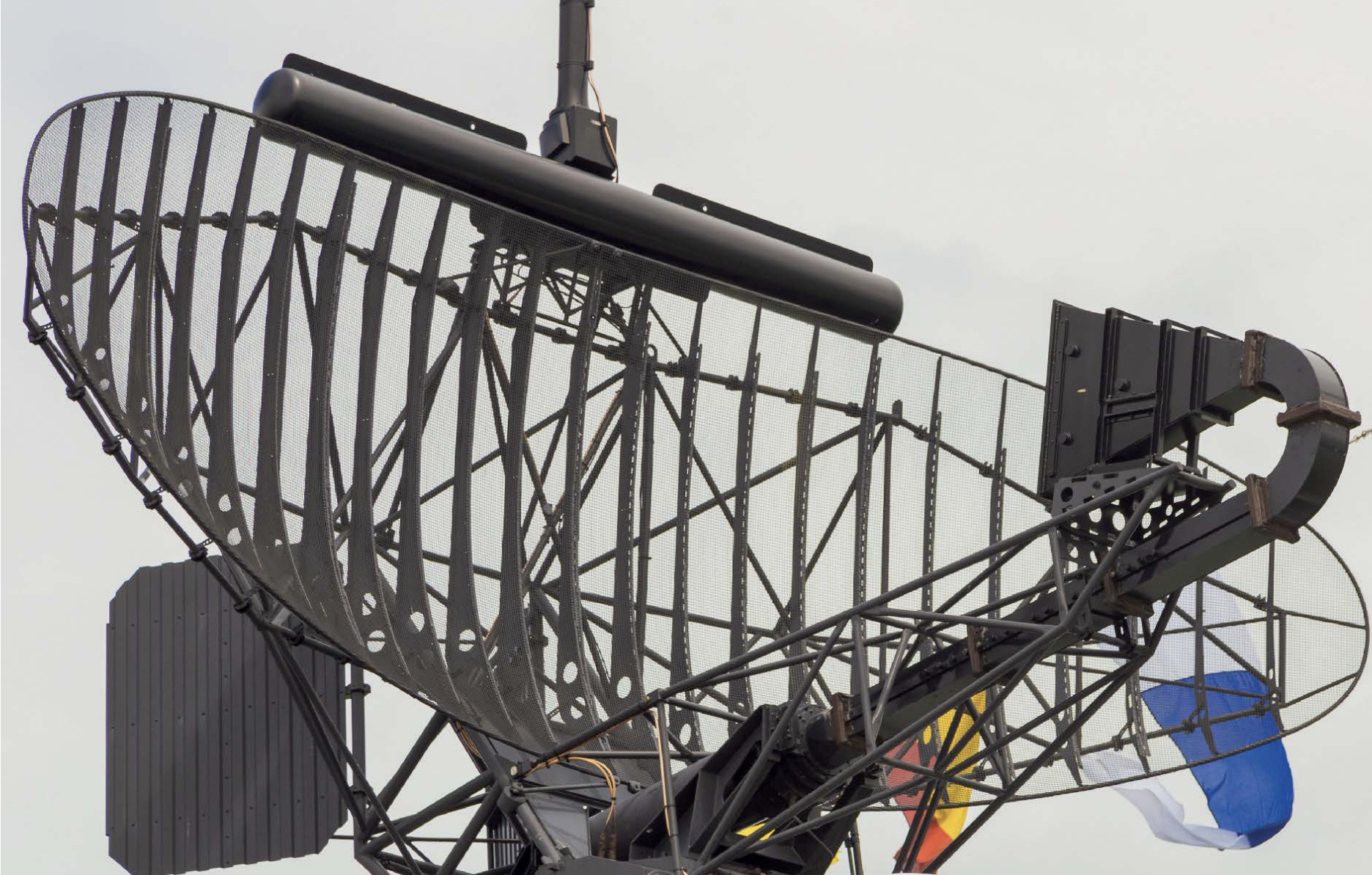
Radar isn't just for weather any more. In aviation, we use radar systems to "see" other aircraft and terrain features, especially in poor visibility conditions. Here's what this sub-topic covers:
- Primary Radar transmits radio waves and measures the reflected echoes to determine the position and distance of other objects. Think of it like shouting and listening for an echo.
- Secondary Radar relies on a transponder onboard other aircraft that replies to a radar signal with its identification and position information. It's like a two-way conversation compared to primary radar's "shout and listen" approach.
Tips for Mastering This:
- Grasp the difference between primary and secondary radar and their limitations.
- Understand how to interpret radar displays and identify potential hazards like other aircraft or terrain.
- Remember, radar information needs to be interpreted alongside other navigational tools to maintain situational awareness.
062.06 Global Navigation Satellite Systems (GNSSs)
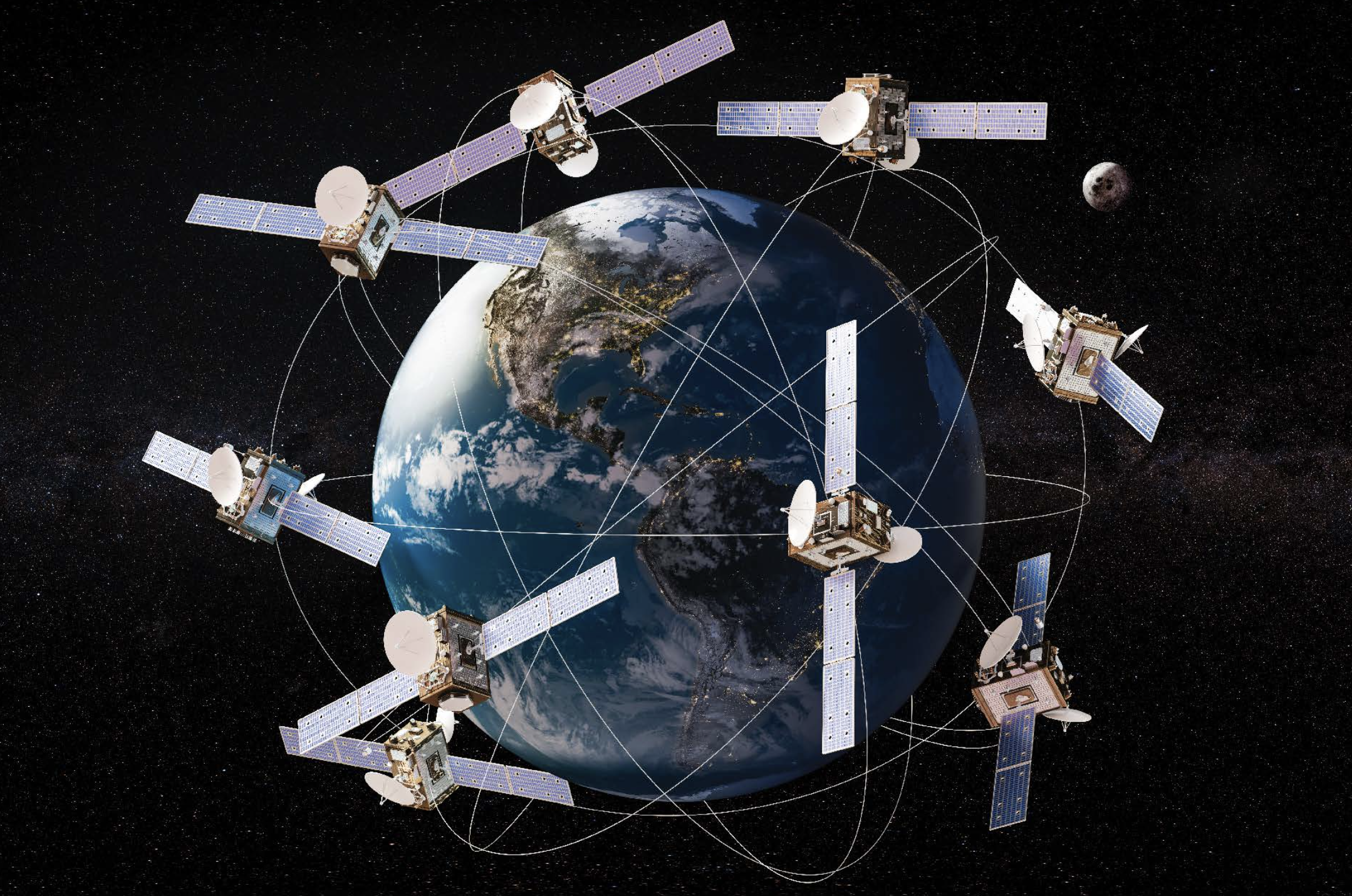
GNSSs, the stalwarts of modern navigation, revolutionise aerial manoeuvres with unparalleled precision. Operating through an intricate web of satellites, these systems furnish aircraft with impeccably accurate positional data across the globe. Under this topic, you will explore:
- GPS (Global Positioning System): Undoubtedly the titan among GNSSs, GPS harnesses a fleet of American satellites to pinpoint aircraft locations with pinpoint accuracy.
- Other GNSS Systems, like Galileo (European Union) and GLONASS (Russia), broaden coverage and fortify redundancy, ensuring navigational reliability even in the most remote regions.
- DGNSS (Differential GNSS): A marvel of precision engineering, DGNSS elevates basic GNSS signals to new heights of accuracy. By deploying ground stations as meticulous calibrators, it fine-tunes positional data with surgical precision, enhancing navigational integrity. Think of it as a fine-tuning mechanism.
- EGNOS (European Geostationary Navigation Overlay Service): This European system augments GPS signals, improving accuracy and reliability in specific regions.
062.07 Performance-Based Navigation (PBN)
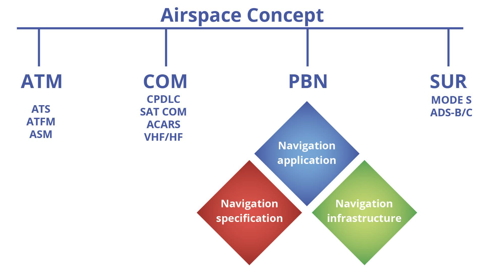
PBN takes navigation to the next level, using a combination of GNSS and other technologies to define flight paths and procedures.
Performance-Based Navigation (PBN) is a sophisticated approach to aircraft navigation that focuses on achieving specific performance criteria rather than relying solely on ground-based navigational aids. In PBN, aircraft are equipped with advanced onboard navigation systems that help them navigate along predefined paths with precise accuracy.
Benefits of PBN:
- Shorter Routes: PBN enables more direct flight paths, reducing fuel consumption and flight times compared to conventional routes that depend on ground-based navaids.
- Cost Efficiency: With fewer ground-based navigational aids required, PBN reduces the infrastructure costs for air navigation service providers.
- Increased Precision: PBN enhances the accuracy of flight paths, which improves safety and allows for more efficient use of airspace.
Key elements of PBN
- Navigation Specifications: These are the set of requirements for aircraft and crew that define the performance needed for a specific operation. They include accuracy, integrity, availability, and continuity requirements.
- Area Navigation (RNAV): A method of navigation that allows aircraft to fly on any desired flight path within the coverage of ground- or space-based navigation aids, or within the limits of self-contained systems. It provides greater flexibility in route planning.
- Required Navigation Performance (RNP): Similar to RNAV, but with the added requirement that the aircraft has onboard performance monitoring and alerting capabilities. This ensures the aircraft can meet specific performance standards throughout the flight.
- Performance-Based Approach and Departure Operations (PBAO/PBDO): These operations apply PBN principles specifically to approaches and departures, ensuring that aircraft can navigate safely and efficiently during these critical phases of flight.
Overall, PBN enhances airspace capacity, improves safety, and supports more environmentally friendly aviation by optimising flight routes and reducing the dependency on ground-based navigational infrastructure.
PBN procedures can be complex, particularly when dealing with RNAV and RNP specifications. Spend extra time understanding these concepts and practising with sample questions.
Mastering concepts of Radio Navigation takes time and practice. Understanding how each navigational aid works, its limitations, and how it's applied in real-world aviation scenarios will not only help you in the exam but also in your flying career.
Remember, confidence is key. Best of luck on your exam!
Examples of Exam Questions
Test your knowledge with these sample Radio Navigation exam questions. These are representative of the types of questions you'll encounter in the actual ATPL examination.